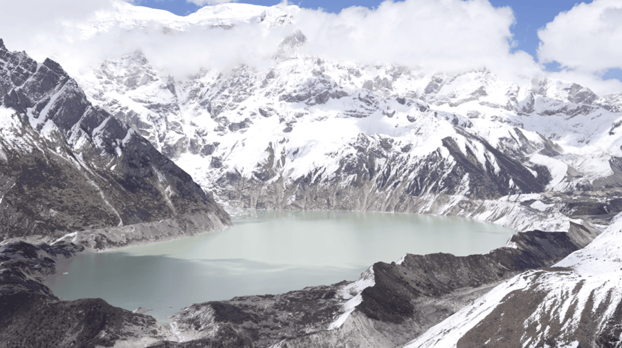
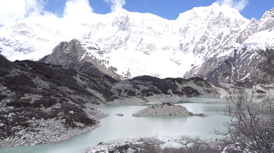
Thorthormi, one of the 17 potentially dangerous lakes in the country, is almost a fully formed lake now. With glaciers receding faster, the risks of a glacial lake outburst flood loom larger than ever. As part of its mitigation efforts, the National Centre for Hydrology and Meteorology is piloting siphoning for the second time to lower the lake’s water level. The team recently assessed a new site at the lake in Lunana.
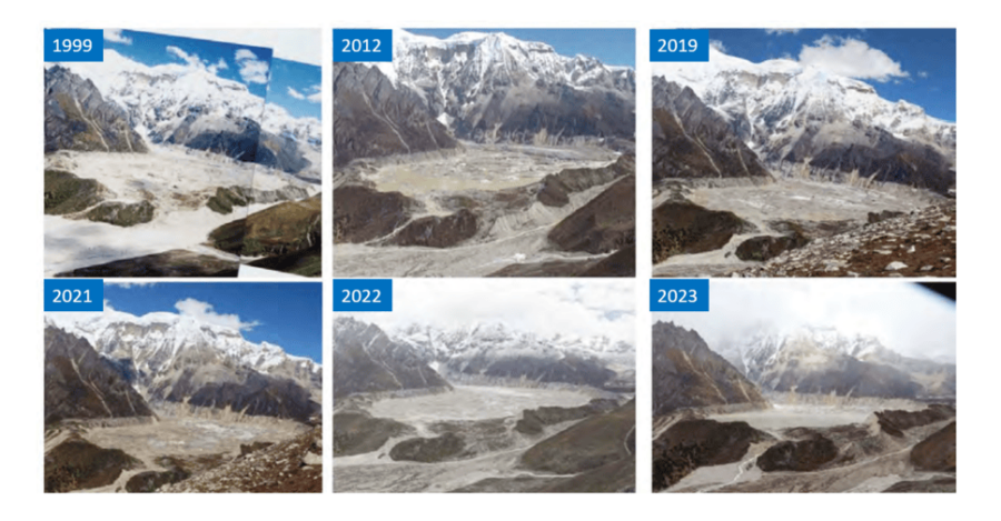
Just a few years ago, the lake was still forming, with small pools of glacial melt gradually merging into a larger water body.
And for the people living nearby, these changes are unfolding rapidly before their eyes.
“During our time, we used to go to Thorthormi to collect firewood. It was a beautiful place where we also took our cattle to graze. It was all glaciers. But now, with rising temperatures, the glaciers are melting faster than ever, and Thorthormi has become a lake,” said Dorji Wangmo, a resident of Thangza-Toenchoe, Lunana Gewog, Gasa.
“I grew up here and used to go to Thorthormi to collect firewood. Back then, it was more like ground with bushes and only a small amount of water. Now, with warmer temperatures, it has turned into a big lake over the past five years. It used to be just small ponds,” said Nima Droji, Thangza-Toenchoe Tshogpa, Lunana Gewog, Gasa.
“In the past, Thorthormi was not a lake. There were rocks and glaciers, and we went there to collect firewood and sang. Now, the lake has become so big,” said Phurpa Dema, a resident of Thangza-Toenchoe, Lunana Gewog, Gasa.
According to a 2023 survey, the lake stretches over four kilometres in length and more than one kilometre in width.
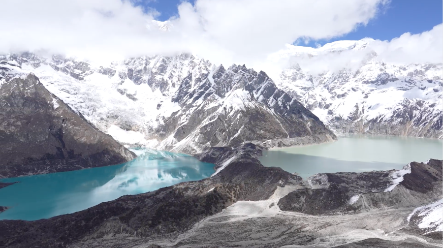
To the left of Thorthormi lies the Raphstreng Lake, which remains relatively harmless under stable conditions. Further left is Baytsho, the smallest among the four major lakes in Lunana, while Luggye lies to the extreme right.
Thorthormi currently poses the greatest threat, particularly due to the fragile moraine wall separating it from Raphstreng.
Experts identify two major risks associated with Thorthormi and the potential for a glacial lake outburst flood.
“Thorthormi sits at a higher elevation than Raphstreng, separated by a moraine dam composed of glacier material. With rising temperatures, this moraine is thinning every year. If the moraine fails, the combined volumes of both lakes will wreak havoc,” said Karma, Chief/Specialist, Cryosphere Services Division.
This represents the worst-case scenario. Experts estimate that the combined water volume could reach 53 million cubic metres: three to four times larger than the devastating 1994 flood from Luggye that wreaked havoc downstream.
“If you look at the surroundings of the outlet of the Thorthormi Lake, the upper layer is soil, but beneath it is glacier ice. This makes the structure unstable. In the event of an avalanche or a large ice mass falling into the lake, it could generate waves strong enough to breach the outlet, triggering a GLOF,” said Karma, Chief/Specialist, Cryosphere Services Division.
The subsidiary lake one, once separated by a moraine, has now merged with the Thorthormi Lake due to rapid ice melt. This is equally concerning as the threat of Thorthormi overtopping Raphstreng.
“Surprisingly, the changes happening on this side are faster. That we cannot ignore. The changes happening here are also very significant and very fast. Last year, when we were here for around two months, in front of our eyes, the ice on this side used to break off and float upward, widening the channel. That means the main lake and the subsidiary lake are getting connected. So now if we look here exactly at the location, now I have done the recent survey, bathymetry survey, just two days before and the depth over there between the channel, the previous channel that we had to have, is now more than six metres. That means the ice beneath is already disappearing and melting,” said Phuntsho Tshering, Principal Meteorology/Hydrology Officer, Cryosphere Services Division.
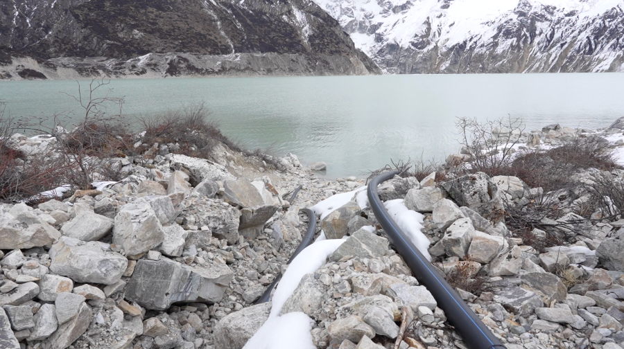 The National Centre for Hydrology and Meteorology tested siphoning from another side of the lake last year, which was ineffective.
“Earlier, there were two major challenges. A barrier prevented effective drainage from the main lake. However, our recent bathymetric survey shows the water depth here has increased to around 12 metres from about three metres last year. This indicates that siphoning from this side may now be feasible,” said Sangay Tenzin, Project Engineer, Hydrology and Water Resources Division.
Another challenge was the fragile terrain near the outlet. However, the team has now conducted detailed assessments using both ground and drone surveys. This time, the centre plans to pilot it from a newly assessed site. The works will begin in September this year.
“This year, we assessed the area through various means, including drone and ground surveys, which helped us understand the situation. With this information in hand, we need to get back to the office and design a suitable siphoning structure. It looks like we can test siphoning here, but cannot confirm it definitively yet,” said Sangay Tenzin, Project Engineer, Hydrology and Water Resources Division.
This time, the siphoning point is much closer to the top of the lake’s natural barrier, at just five to six metres. Last year, the height was over nine metres, making the effort less effective.
If successful, Bhutan will become the first country in the region to effectively mitigate GLOF threats using siphoning.
As Thorthormi continues to expand at an alarming pace, the success of this pilot could prove critical, not just in lowering the lake’s water level but in safeguarding communities downstream from a disaster that is no longer a distant threat.
Devika Pradhan, Lunana
Edited by Phub Gyem